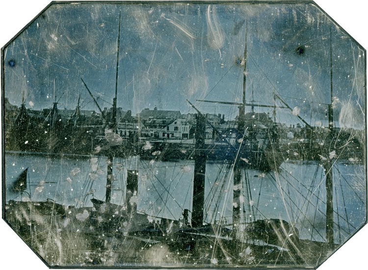
In May 2019, an intriguing full-plate daguerreotype titled Port de la côte normande ou bretonne, ca. 1845 was sold at the Hôtel Drouot. If the expert in charge of describing this mysterious landscape was able with reason to circumscribe the area around the Channel and the Channel Islands, he ended his report with: no monument allows us to identify precisely the place. But that was without counting on the trained and attentive eye of the “local iconophile”, who, faced with an unknown document, manages sometimes to recognize his city of predilection by the mere presence of buildings that have disappeared or are insignificant in the eyes of the layman. In the port landscape that interests us here, several elements allow us to identify with certainty a forgotten corner of the old Le Havre, which disappeared over the course of the 19th century.
After a technical description of the daguerreotype in question, we will specify its dating and will make some hypotheses as to its author. We will then analyze in detail the moving photographic testimony that constitutes this archival piece of rare documentary interest.
Technical description of the object
First of all, it is worth taking a moment to look at the technical characteristics of our daguerreotype.
Dimensions
We have a copper plate lined with silver, 20 cm wide by 24.8 cm long ; it can therefore be classified in the “full-plate” category, meaning the largest of the formats commonly produced in the Daguerrian period. Note, however, the presence of a margin between the edge of the plate and the recorded image, which brings the dimensions of the view to 14.5 x 20 cm. Despite this, this Daguerrian image remains much superior in size to other daguerreotypes that have been identified as taken in Le Havre (around thirteen identified to date).
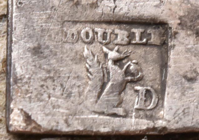
Markings
In a corner of the plate (top left of the obverse) a discreet hallmark has been affixed (fig.2). In a classic form, it contains the following usual information:
• The mention “doublé” (plated) indicating that the plate is not entirely composed of silver, but only plated.
• The manufacturer’s mark, meaning the symbol specific to the manufacturer or the original workshop (here, the right profile of a squirrel carrying a hazelnut).
• The manufacturer’s initial last name (the letter of the first name happened to be erased).
Other considerations
First, the fact that the image does not show a specular inversion reveals to us that the camera was equipped with a rectifier accessory (mirror or prism).
Second, on the back of the plate, traces of smoke are visible, which suggests the fixing of the image by gold toning.
Third, in view of the multiple alterations undergone by our daguerreotype, we can see that it has not always been preserved in the best conditions. The main damage observed is of a mechanical nature and undoubtedly resulted from improper handling (scratches and friction marks). Other damages are probably due to chemical reactions due to atmospheric pollution and humidity.
A specified date
If, at first, there is no reason to dispute the dating established in 2019 by the expert from the Hôtel Drouot, dated circa 1845, today we have several chronological indications that allow us to clarify things a little ; one of these clues being technical, the others consist of details of the landscape being photographed.
Technical indications
First, we were able to establish that the hallmark mentioned above (right profile of a squirrel carrying a hazelnut, flanked by the letter “D”), was very probably affixed by the manufacturer of plates Eugène Dumont (1820-?), who was at the time located in Paris at 23 rue Jean-Robert.1Over a period of at least 70 years, the trademark symbolized by “the right profile of a squirrel carrying a hazelnut” was transmitted between each of the silversmiths who succeeded one another within the same workshop located at 75 rue des Gravilliers, in Paris. This strongly suggests that this trademark came from the very founder of the workshop, a certain Eugène Dumont. However, before 1852, the year he moved to 75 rue des Gravilliers, Dumont practiced at 23 rue Jean-Robert.
Although Dumont’s first registration in the general business directory dates from 1846, his workshop could as well have opened its doors just after a census possibly taken the previous year. This “Dumont hypothesis” – more than probable in our opinion – has us retain the year 1845 as the lower chronological date for the manufacturing of the plate, and, consequently, for its use by the daguerreotypist who acquired it.
Landscape indications
Some details of the recorded landscape also deserve special attention.
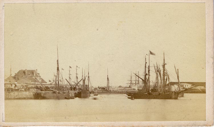
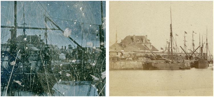
First, the aspect presented by the south-west side of the old citadel. We know that in the mid-1840s, a surrounding wall, lined with loopholes and flanked by bastions, was built around the old citadel of Le Havre in order to establish a military reduit in this location. If we do not know the precise period of construction of this section, we do know that in February 1846, the building site was in progress.2Chamber of Deputies of France: minutes of the sessions of the chamber of representatives to the legislative body (1815-1847), ed. Henry, session of February 25, 1846, p.163. However, on our daguerreotype, we can see clearly that the main element of this reduit, namely its surrounding wall, had not yet been erected. To be certain of this, there is another photograph (also quite unique) taken from a comparable angle, on which the completed wall of the section clearly appears (fig.3). Although it is possible that the construction of the reduit had already started by the time the daguerreotype was made, at best it could only have been in its early stages. This is why we would tend to date the image taken to 1847 at the latest.
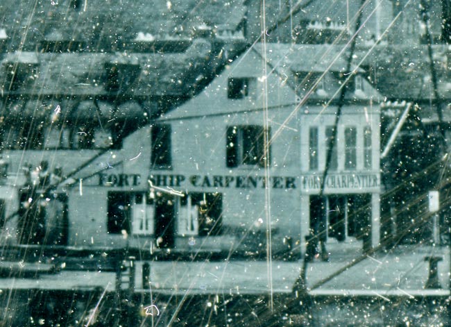
Another landscape clue that should be taken into consideration: this house, located in the center of the image, and on which there is a perfectly legible sign (FORT. SHIP CARPENTER / FORT CHARPENTIER). This is a house built in 1828 by a shipwright by the name of Jean Michel Charles Fort (we’ll come back to him later). He remained active at this address in the Germain district (2 quai du Gril) until 1848, after which he set up his business at 11 quai de l’Ile, in the Saint-François district. An article published in June 1848 in the Courrier du Havre sheds light on the probable reason for this move. We read: The order has arrived to complete the work on the citadel ; the houses in the Germain district will be demolished. From Monday, communications will be interrupted between the reduit and the citadel barrier ; there will only be passage on a service bridge established at the end of rue du Port.3Article reported in Le Courrier Français of Friday, June 16, 1848. This information strongly incites us to retain the year 1848 as the latest chronological indication for when the image was taken.
Conclusion
A new date range can be put forward: between 1845-1848.
Attribution hypothesis
Apart from a relatively narrowly circumscribed date of shot, and the fact that the blank plate was undoubtedly made in Paris by Eugène Dumont, we currently have no other clue that would allow us to identify the photographer. Despite everything, we have a few plausible contenders, namely the only three daguerreotypists who – to our knowledge – were already active in Le Havre at the time in question.
The Autin brothers
Originally from Harfleur, near Le Havre, the Autin brothers were among the very first professional photographers in Normandy. Around 1840, they opened a workshop in Caen, on the passage Bellivet.
Auguste Autin (1809-1889)
Auguste Autin worked in Le Havre in 1843 as an itinerant portraitist. At the time, he also gave lessons on daguerreotype photography and sold the materials necessary for its practice. During his stays in Le Havre, he lived in the Saint-François district, where he also settled with his wife. In 1846, he lived on quai de l’Ile, and established himself the following year as a “painter” at 2 rue Royale [du Général-Faidherbe]. These two addresses are not far from the place where the view that interests us was recorded, and we will come back to this.
We currently know of three daguerreotypes signed Auguste Autin, plus a fourth attributable to the same photographer. These are exclusively portraits, all are kept in the departmental archives of the Calvados.
Edmond Autin (1817-1866)
Edmond Autin was also in Le Havre in 1846. There, he had the occupation of “daguerreotypeur”, place de la Comédie [du Général-de-Gaulle]. In addition to portraits, he produced reproductions of paintings, views and landscapes. Like his older brother, he gave lessons in daguerreotype and sold the equipment necessary for this discipline.
Only one daguerreotype of Edmond Autin is known, an anonymous portrait of a young man currently in the Bergen City Museum, Norway
Schneider Chrétien (ca.1816-?)
Little is known about this daguerreotypist except that in 1846 he took an outdoor portrait of the Langer family.4Schneider Chrétien, Famille Langer, 4 août 1846, un-straightened daguerreotype (7.5 x 9.5 cm), municipal archives of Le Havre, 10Fi1. He lived at 64 rue de Montivilliers, in Ingouville (at the time, suburb of Le Havre).
At the moment, we do not know if any of the six plates mentioned above have any hallmarks. Research in this direction could possibly reveal a link between our anonymous daguerreotype and one or the other of the six, which could support an attribution hypothesis.
A vanished landscape revealed
Let us come to the heart of our subject, which is this intriguing port landscape captured at the very beginning of the photographic era. In addition to its date, the view reveals a sector that is almost absent from Le Havre’s iconography. As a result, it constitutes an invaluable contribution to the topographical knowledge of the old city and its port.
The location
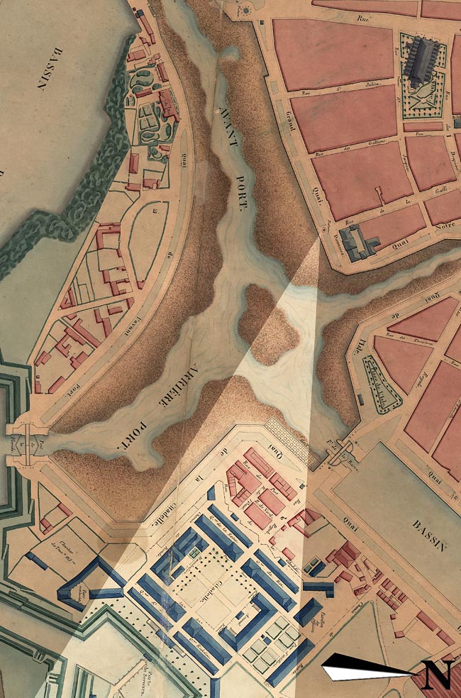
Thanks to a few perfectly identifiable landmarks in our image, and the existence of a very detailed period map (fig.7), it was possible for us – by deferral and alignment of these landmarks – to deduce fairly precisely the location of where the image was taken.
It was at the end of the Grand-Quai [Quai de Southampton], not far from customs and the Hôtel de Londres, at the outlet of rue de la Gaffe, that our anonymous daguerreotypist took up his position.
Focusing his gaze on the vast expanse of water in front of him (that of the inner harbor), he decided to direct his camera due east, in the direction of the citadel. Then, once satisfied with his framing, he executed the work needed to obtain the daguerrian landscape which we propose to analyze here.
In the days of paddle wheels
In the foreground, two steamboats are moored side by side at the Grand-Quai ; they were probably half docked on the mud. At this moment, the sea is relatively low, as indicated to us in the background, a quay wall is visible in its entire height. Let us not forget that at the time, this part of the port of Le Havre (directly connected to the sea) dried up with each tide and under these conditions, only ships capable of withstanding the grounding without danger could station there.
In the 1840s, along the Grand-Quai, small steamers would moor and provide the link between Le Havre and the Norman ports of Honfleur, Trouville, Caen, Cherbourg and Rouen. The two steamers photographed were therefore probably part of this means of passenger transportation. Even if nothing in our image allows us to identify them precisely, the presence of some characteristic elements of the times, such as the masts without a yard or again this very tall and narrow chimney, adorned with a crown (similar as the one owned by the steamer Le Français). The chimney of the first ship, on the left, has a colored segment. Other details are visible: many shrouds, a ship’s steering wheel, a flag, davits (including one supporting a dinghy), the guard of a paddle wheel…
An overview of Port-Neuf: the quai de la Citadelle
The quay appearing in the background – which in places can be guessed rather than seen – is designated “Quai de la Citadelle” on the period map already mentioned. However, in this mid-19th century when odonyms were still vague, the two perpendicular sections of this quay (separated by a cutaway) were sometimes designated differently: “Quai du Gril” and “Quai aux Bois ”, oriented to the north-west and south-west respectively.
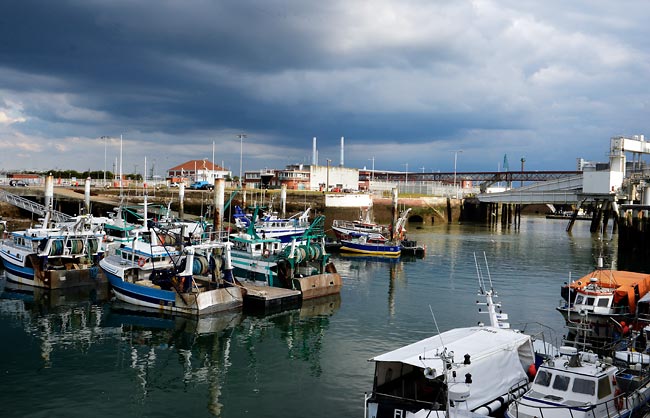
Photograph by Eric Houri, 2021.
The part occupying the left of the image was commonly called “Quai du Gril” because of the careening grid which had been at its foot since 1825. Unfortunately, this port equipment which essentially consisted of a platform frame, is almost invisible in our image and only one of the ladders that gave access to it clearly appears. The grid can be guessed all the same in the form of a clear line, parallel to the foot of the quay, and above which emerge the three masts of the sailboat moored there for careening. We can also observe that for the occasion, the masts of the ship have been lowered and its lower yards have been peaked. Let us add that the quai du Gril, completed at the same time as the quai Lamandé (1820), was sometimes nominally assimilated to the latter.5It is true that the quai du Gril was the exact extension of the quai Lamandé, beyond the south lock of the bassin de la Barre.
In the center of the image, appears the cutaway part of the quai de la Citadelle. It was designed this way during the construction of the inner harbor (or Port-Neuf), for the sake of navigability. Let us note that the Port-Neuf was opened to commerce on November 3, 1835, only ten years before it was photographed ; it therefore still deserved this appellation. Note also, at the height of the cutaway, the presence of a mooring post and a capstan.
Let us now look at the part of the quai de la Citadelle located to the right of the image. The custom had designated it “Quai aux Bois” because bundles of wood were commonly unloaded there, but here, few things are recognizable: two huts (of unknown use) and a volute street lamp typical in Le Havre of this time.6Pierre-François Frissard had these cast iron street lamps installed around the quays of the old and the new outer harbor, at all the locks, and on the west quay of the bassin de la Barre.
Finally, it should be noted that of the 250 meters of quay mentioned above, only a section of approximately 60 meters remains, corresponding to the old quai du Gril, and where the trawlers are still careened today. This two-century-old section forms the north-western front of the current môle de la Manche. The rest of the quai de la Citadelle, meanwhile, disappeared at the end of the 1860s with the construction of the basin bearing the same name.
The Germain district still intact
Among the most interesting elements of the landscape considered here is undoubtedly the Germain district, which can be clearly seen in the center of the image. This small port district of the old Le Havre (barely one hectare in area), built on the former north-western front of the citadel, remains unknown, or even ignored, no doubt because of its short existence (1816-1856), but also because only a few snippets of information and very few figurative documents exist that could give an us an idea of what it would have looked like. The fact remains that in the mid-1840s, the Germain district was still there, wedged between the barracks of the old citadel and the quay of the same name. Five small streets crossed the quarter, some of which were lined with shops and stalls. The 300 inhabitants, for the most part of modest backgrounds, exercised professions as diverse as sailor, day laborer, grocer, shoemaker or liquor shopkeeper.
It should be noted that in 1837, Pierre-François Frissard (1787-1854) then chief engineer of the port of Le Havre, considered this district as the least beautiful, and the dirtiest of the whole city.7Pierre-François Frissard, Histoire du port du Havre, ed. Lemale, Le Havre, 1837, p.345. This is not, however, the impression left by the few facades of the quai aux Bois, visible on our daguerreotype, which even seem to have been built with particular care.
Be that as it may, between 1846 and 1856, the Germain district was demolished in successive stages to make room for a military reduit and to clear the quai de la Citadelle where the construction of a dry dock was planned, but was never realized according to the scheduled plan.
Luckily, at the exact time that interests us here, a young boy keen on drawing lived just opposite the Germain district, at 15 quai de l’Ile. This budding watercolorist was none other than Eugène Grandin (1833-1919), a future ship portrait painter, now well known to amateurs. One fine day in 1847, young Eugène had the good idea to draw the view that was offered to him from his home. The watercolor drawing he produced that day (fig.10) shows in detail the houses and other buildings which followed one another on the quai du Gril ; some signs are even legible there. By comparing this drawing to the Le Havre population census registry of 1846, we were able to identify the inhabitants of each of the buildings represented by Grandin. We will limit ourselves with evoking those who are also found on our daguerreotype.
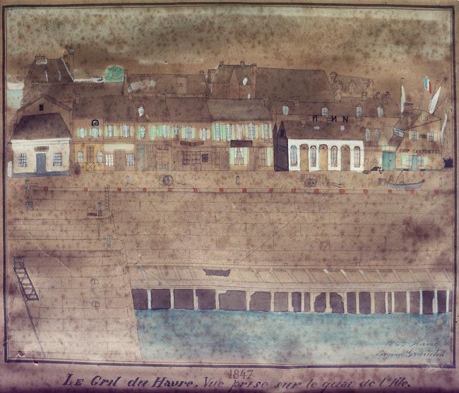
First of all, this oblong one-story building, with rounded openings. Most likely a store assigned to the Ponts & Chaussées department. At this address, in fact, was listed a certain Pierre Louis Pépin, bridge operator by trade, who lived there with his wife. Note that a swing bridge called Pont de la Barre was located in the immediate vicinity.
An extension of this building is a wall with a double-leaf door, which gave access to a courtyard and the home of the guardian of the grid. This position was at the time occupied by Jean Julien Michel who lived there with his wife and daughter.
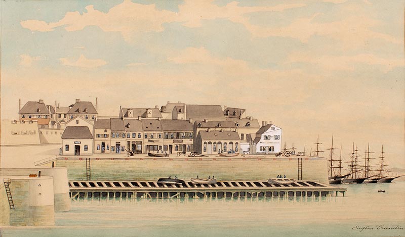
We also notice, in this same place of the quai du Gril, long squared logs, stored on the ground. Nothing very surprising, because here precisely was an open-air shipyard, specializing in the construction of small boats (canoes and pirogues).
We then see the building attached to this shipyard: a light-colored corner house, remarkable for its imposing gabled facade, and on which one can read the sign of the master carpenter who owned the premises (fig. 5). By its color and its dimensions, this construction stands out clearly in the full center of the image and immediately captures the viewer’s attention, to such an extent that one might be tempted to make it the main element of the photographed view.
In addition, the double sign on which is inscribed in large characters “FORT. SHIP CARPENTER / FORT CHARPENTIER” adds an additional emotional charge to our document, and constitutes an irresistible invitation to meet the life of the man hidden behind this surname. We therefore sought to find out more about this so-called Fort, and had the pleasant surprise to discover not only a renowned master carpenter, but also a true figure of Le Havre party life, much appreciated by his contemporaries.
A biographical sketch of this colorful character is included here.
The “citadel” before the construction of the military reduit
To end this presentation, let’s move on to another urban entity, also almost absent from the iconography of Le Havre, namely, the citadel as it appeared in the first half of the 19th century.
To tell the truth, at the time the image was taken, the citadel of Le Havre had not been one for a long time. The external defenses with which Richelieu had built it (second quarter of the 17th century) had all disappeared in the 1780s, with the exception of a portion of the south-eastern front oriented towards the mouth of the Seine. There were also the interior buildings of the old fortress, as well as the vast center around which they had been built. Ultimately, it was no more than a quadrangular set of military buildings, devoid of any enclosure, plus a few other ancillary buildings, which were improperly designated under the term “citadel”. Everyone could still freely access this sector of Le Havre, but soon, the establishment of a vast reduit would again surround it with a ditch and a bastion wall.
Although on our daguerreotype the “citadel” is almost entirely hidden by the Germain district, it is possible to distinguish its south-west side – directly open on the quai aux Bois – plus a few military pavilions whose high roofs emerge with difficulty in the background. We were thus able to identify from left to right of the document (see fig. 8).
The officers’ pavilion
This building, as imposing as it is not well known, dominated the surrounding landscape since the end of the 18th century, the date of its construction. Its steeply sloping roof, pierced with tall chimney stacks and a double row of dormers, was reminiscent of certain shipowners’ hotels built a few decades earlier on the ramparts of Saint-Malo.
On our daguerreotype, only the eastern end of this roof appears to us to the far left of the image.
In the officers’ pavilion lodged Lieutenant-Colonel Léandre François Régis Hocédé (1791-1855) who, at the time in question, held the command of the place of Le Havre.
The north-west wing of the arsenal
The arsenal of the citadel was the only building dating from Richelieu to have retained its original use ; it could hold 25,000 rifles. Each of the two wings perpendicular to its main body was adorned with a beautiful fountain overlooking the place of arms.
Unfortunately here, only a high part of the north-west wing is given to us to see, in this case, the outer slope of its roof and three of the four hipped dormers with which it was equipped.
The staff pavilions
Four in total, they were similar in architecture and symmetrically arranged. These buildings were built in 1760 on the inside of the citadel to enlarge the four long red brick barracks, known as quarters, which dated from Richelieu.
On our daguerreotype, only high roofs and imposing chimney stacks belonging to three of these pavilions stand out, the fourth being entirely hidden by an enormous unidentified building in the Germain district. From left to right, we have identified the pavilions of staff assigned respectively to engineers, artillery and stewardship.
The military bakery (former Governors’ hotel)
This building with its facade decorated with Corinthian columns, also dated from the time of Richelieu. It lost its prestigious destination as the dwelling of the King’s Lieutenant in 1779, after its last resident, Count François-Xavier de Virieu-Beauvoir (1709-1782), ordered the construction of a new hotel near the port entrance. From that date on, the citadel’s old house was allocated more modestly to the making and preservation of bread for the garrison and to military bakers’ accommodation. We also know that, around 1834, its vaulted cellars were used to store whale oil ; perhaps it was still the case at the time the image was taken?
On our daguerreotype, we can clearly distinguish the north-west wing of the building, which was covered with two twin roofs. The central body of one storey topped with a four-sided roof also appears, dominating the quai aux Bois (fig. 4).
To conclude this chapter, let us specify that all the buildings that belonged to the old citadel of Le Havre were completely demolished in 1865 in order to allow the construction of new port infrastructures (basin, lock chamber, dry docks).
An approach to be pursued…
As we have seen, the photograph presented here undeniably constitutes, by its date (ca. 1845-1848), its nature (daguerreotype “in the open air”), its dimensions (full plate format), and its subject (a forgotten corner from the old Le Havre), a very important archive piece, at least on a regional scale.
Hopefully in the near future, a museum will be able to acquire it so that the valuation process that we have tried to initiate here can be continued.
In particular, a more in-depth technical diagnosis should be undertaken with regard to this precious daguerreotype, with a view to a possible restoration.
Heartfelt thanks to Tiphaine Brajeux, Gabriele Chiesa, Chantal Davourie, Bruno Delarue, Christophe Fauque, Daniel Haté, Eric Houri, Suzanne Inge, Valéry Lebigot, Sébastien Lemagnen, Raynald Maheut, Claire Pedrazzoli, Adnan Sezer, Bruno Tartarin, Philippe Valetoux et Thierry Vincent.
To contact the author: